Cette carte est interactive ! Utilisez les boutons pour zoomer ou vous déplacer.
Accès
|
English (Traduisez ce texte en Français): The Grand Narrows dive site is accessed from Highway 223. Thee site is approximately 62 km from Sydney or 25 km from the Trans Canada via Little Narrows. An entrance through the guard rail is positioned 0.3 km east of the car drawbridge; parking is at the beach.
English (Traduisez ce texte en Français): The Grand Narrows dive site is accessed from Highway 223. Thee site is approximately 62 km from Sydney or 25 km from the Trans Canada via Little Narrows. An entrance through the guard rail is positioned 0.3 km east of the car drawbridge; parking is at the beach.
The Grand Narrows dive site is accessed from Highway 223. Thee site is approximately 62 km from Sydney or 25 km from the Trans Canada via Little Narrows. An entrance through the guard rail is positioned 0.3 km east of the car drawbridge; parking is at the beach.
English (Traduisez ce texte en Français): The Grand Narrows dive site is accessed from Highway 223. Thee site is approximately 62 km from Sydney or 25 km from the Trans Canada via Little Narrows. An entrance through the guard rail is positioned 0.3 km east of the car drawbridge; parking is at the beach.
English (Traduisez ce texte en Français): The Grand Narrows dive site is accessed from Highway 223. Thee site is approximately 62 km from Sydney or 25 km from the Trans Canada via Little Narrows. An entrance through the guard rail is positioned 0.3 km east of the car drawbridge; parking is at the beach.
English (Traduisez ce texte en Français): The Grand Narrows dive site is accessed from Highway 223. Thee site is approximately 62 km from Sydney or 25 km from the Trans Canada via Little Narrows. An entrance through the guard rail is positioned 0.3 km east of the car drawbridge; parking is at the beach.
English (Traduisez ce texte en Français): The Grand Narrows dive site is accessed from Highway 223. Thee site is approximately 62 km from Sydney or 25 km from the Trans Canada via Little Narrows. An entrance through the guard rail is positioned 0.3 km east of the car drawbridge; parking is at the beach.
English (Traduisez ce texte en Français): The Grand Narrows dive site is accessed from Highway 223. Thee site is approximately 62 km from Sydney or 25 km from the Trans Canada via Little Narrows. An entrance through the guard rail is positioned 0.3 km east of the car drawbridge; parking is at the beach.
English (Traduisez ce texte en Français): The Grand Narrows dive site is accessed from Highway 223. Thee site is approximately 62 km from Sydney or 25 km from the Trans Canada via Little Narrows. An entrance through the guard rail is positioned 0.3 km east of the car drawbridge; parking is at the beach.
Comment ? Depuis le bord
Distance Accès direct
Facile à trouver ? Facile à trouver
|
|
Caractéristiques du site
Autre nom Kaleva Wreck
Prof. moyenne 10.1 m / 33.1 ft
Prof. max 20.1 m / 65.9 ft
Courant Moyen ( 1-2 knots)
Visibilité Moyen ( 5 - 10 m)
Qualité
Qualité du site Normal
Expérience CMAS * / OW
Intérêt bio Intéressant
Plus d'infos
Fréquentation semaine
Fréquentation week-end
Type de plongée
- Dérivante
- Epave
Activités plongée
- Biologie Marine
- Orientation
- Photographie
Dangers
- Courant
- Trafic de bateaux
Informations supplémentaires
English (Traduisez ce texte en Français): Divers unfamiliar with the site should travel with a guide due to potential strong currents, depth, boat traffic, fish that like to nip at unwary divers, and the maze of underwater structures.
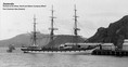
The dive site is best known for the abundance of marine life and the wreck that lies only 200 ft from the beach. Research conducted by the Baddeck Barnacles Diving Society in 2014 concluded that the reek is the final resting place of the Zealandia. The ship was built as a 3 masted, full-rigged clipper with an iron hull (No. 60969) by C. Connell and Co. in Glasgow in 1869. From 1870-1902 she served as a passenger/cargo ship for the Shaw, Savill and Albion Line of London, carrying over 4000 immigrants to New Zealand. Sold several times between 1902 and 1911 she was renamed Kaleva in 1907. Wrecked on Pumpkin Island Nova Scotia in 1911 she was salvaged and converted to a barge by Charles Brister of Halifax. In July 1916 she broke tow during a gale and sank after crashing into the Barra Strait railway bridge with a load of dolomite bound for Sydney. The wreck is 220 ft long by 40 ft wide and at the stern, it rises 30 ft off the bottom. At the wreck the maximum depth is 68 ft. Note because the wreck had been converted to a barge; most of upper deck structure was removed providing access to the inside of the bath tub like hull. Divers are advised however to avoid swimming under the remaining deck framing as the pieces could be loose. To aid getting on the wreck a rope is usually in place, extending from the beach to train swing bridge pivot support.
Although the wreck is the main attraction other structures merit exploration. A submerged wooden cribbed wharf extending approximately 300 ft to the south and parallel to the boat channel offers wall diving with depths ranging from 15 to 70 feet. Current most be considered here, but with careful planning this Site can make a terrific drift dive.
English (Traduisez ce texte en Français): Divers unfamiliar with the site should travel with a guide due to potential strong currents, depth, boat traffic, fish that like to nip at unwary divers, and the maze of underwater structures.
The dive site is best known for the abundance of marine life and the wreck that lies only 200 ft from the beach. Research conducted by the Baddeck Barnacles Diving Society in 2014 concluded that the reek is the final resting place of the Zealandia. The ship was built as a 3 masted, full-rigged clipper with an iron hull (No. 60969) by C. Connell and Co. in Glasgow in 1869. From 1870-1902 she served as a passenger/cargo ship for the Shaw, Savill and Albion Line of London, carrying over 4000 immigrants to New Zealand. Sold several times between 1902 and 1911 she was renamed Kaleva in 1907. Wrecked on Pumpkin Island Nova Scotia in 1911 she was salvaged and converted to a barge by Charles Brister of Halifax. In July 1916 she broke tow during a gale and sank after crashing into the Barra Strait railway bridge with a load of dolomite bound for Sydney. The wreck is 220 ft long by 40 ft wide and at the stern, it rises 30 ft off the bottom. At the wreck the maximum depth is 68 ft. Note because the wreck had been converted to a barge; most of upper deck structure was removed providing access to the inside of the bath tub like hull. Divers are advised however to avoid swimming under the remaining deck framing as the pieces could be loose. To aid getting on the wreck a rope is usually in place, extending from the beach to train swing bridge pivot support.
Although the wreck is the main attraction other structures merit exploration. A submerged wooden cribbed wharf extending approximately 300 ft to the south and parallel to the boat channel offers wall diving with depths ranging from 15 to 70 feet. Current most be considered here, but with careful planning this Site can make a terrific drift dive.
Divers unfamiliar with the site should travel with a guide due to potential strong currents, depth, boat traffic, fish that like to nip at unwary divers, and the maze of underwater structures.
The dive site is best known for the abundance of marine life and the wreck that lies only 200 ft from the beach. Research conducted by the Baddeck Barnacles Diving Society in 2014 concluded that the reek is the final resting place of the Zealandia. The ship was built as a 3 masted, full-rigged clipper with an iron hull (No. 60969) by C. Connell and Co. in Glasgow in 1869. From 1870-1902 she served as a passenger/cargo ship for the Shaw, Savill and Albion Line of London, carrying over 4000 immigrants to New Zealand. Sold several times between 1902 and 1911 she was renamed Kaleva in 1907. Wrecked on Pumpkin Island Nova Scotia in 1911 she was salvaged and converted to a barge by Charles Brister of Halifax. In July 1916 she broke tow during a gale and sank after crashing into the Barra Strait railway bridge with a load of dolomite bound for Sydney. The wreck is 220 ft long by 40 ft wide and at the stern, it rises 30 ft off the bottom. At the wreck the maximum depth is 68 ft. Note because the wreck had been converted to a barge; most of upper deck structure was removed providing access to the inside of the bath tub like hull. Divers are advised however to avoid swimming under the remaining deck framing as the pieces could be loose. To aid getting on the wreck a rope is usually in place, extending from the beach to train swing bridge pivot support.
Although the wreck is the main attraction other structures merit exploration. A submerged wooden cribbed wharf extending approximately 300 ft to the south and parallel to the boat channel offers wall diving with depths ranging from 15 to 70 feet. Current most be considered here, but with careful planning this Site can make a terrific drift dive.
English (Traduisez ce texte en Français): Divers unfamiliar with the site should travel with a guide due to potential strong currents, depth, boat traffic, fish that like to nip at unwary divers, and the maze of underwater structures.
The dive site is best known for the abundance of marine life and the wreck that lies only 200 ft from the beach. Research conducted by the Baddeck Barnacles Diving Society in 2014 concluded that the reek is the final resting place of the Zealandia. The ship was built as a 3 masted, full-rigged clipper with an iron hull (No. 60969) by C. Connell and Co. in Glasgow in 1869. From 1870-1902 she served as a passenger/cargo ship for the Shaw, Savill and Albion Line of London, carrying over 4000 immigrants to New Zealand. Sold several times between 1902 and 1911 she was renamed Kaleva in 1907. Wrecked on Pumpkin Island Nova Scotia in 1911 she was salvaged and converted to a barge by Charles Brister of Halifax. In July 1916 she broke tow during a gale and sank after crashing into the Barra Strait railway bridge with a load of dolomite bound for Sydney. The wreck is 220 ft long by 40 ft wide and at the stern, it rises 30 ft off the bottom. At the wreck the maximum depth is 68 ft. Note because the wreck had been converted to a barge; most of upper deck structure was removed providing access to the inside of the bath tub like hull. Divers are advised however to avoid swimming under the remaining deck framing as the pieces could be loose. To aid getting on the wreck a rope is usually in place, extending from the beach to train swing bridge pivot support.
Although the wreck is the main attraction other structures merit exploration. A submerged wooden cribbed wharf extending approximately 300 ft to the south and parallel to the boat channel offers wall diving with depths ranging from 15 to 70 feet. Current most be considered here, but with careful planning this Site can make a terrific drift dive.
 Commentaires
Tout voir (0)...
Soyez le(la) premier(e) à commenter ce pays
Erreurs, Réactions
Vous pouvez corriger des erreurs ou ajouter de nouvelles informations sur cette page. Si vous avez d'autres commentaires à faire sur cette page, Dite-le nous.
 Zealandia Wreck & Grand Narrows