Mot de passe perdu ?
Nouvel utilisateur ? Créer un compte
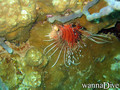
Clownfish, Philippines. Photo by Stephane Rochon.
Appréciez et contribuez !
| Trouvez les meilleurs sites |
|
|
![]() Mayotte
Mayotte
Afrique
Localisation: Southern Indian Ocean, island in the Mozambique Channel, about half way between northern Madagascar and northern Mozambique
Coordonnées géographiques: 12° 30' S, 45° 6' E
Côte: 185.2 km km
Climat: tropical; marine; hot, humid, rainy season during northeastern monsoon (November to May); dry season is cooler (May to November)
Relief: generally undulating, with deep ravines and ancient volcanic peaks
Sommets: lowest point: Indian Ocean 0 m
highest point: Benara 660 m
Risques naturels: cyclones during rainy season
Monnaie: euros (EUR)
Population: 223,765 (July 2009 est.)
Langues: Mahorian (a Swahili dialect), French (official language) spoken by 35% of the population
Capitale: Mamoudzou
Découpage administratif: none (territorial overseas collectivity of France)
Plus d'informations
| Jan | Feb | Mar | Apr | May | Jun | Jul | Aug | Sep | Oct | Nov | Dec | |
|---|---|---|---|---|---|---|---|---|---|---|---|---|
| Climate | ||||||||||||
| Air temp. | ||||||||||||
| Water temp. | ||||||||||||
| Equipment | Keine Ahnung | Keine Ahnung | Keine Ahnung | Keine Ahnung | Keine Ahnung | Keine Ahnung | Keine Ahnung | Keine Ahnung | Keine Ahnung | Keine Ahnung | Keine Ahnung | Keine Ahnung |
| Best season | ||||||||||||
Vous voulez ajouter des informations sur Mayotte? Dites-le nous...
Cette carte est interactive ! Utilisez les boutons pour zoomer ou vous déplacer.
- Favoris
-
Vos sites favoris et futures listes de sites
Sites de plongée
| Sites de plongée (3) | Qualité | Prof moy | Prof max | Expérience | Type de plongée | ||
|---|---|---|---|---|---|---|---|
| Mtsangamouji | - / - | 4 m | 50 m | Tous niveaux | 


|
||
| Passe bandrélé - Les ancres | - / - | 10 m | 18 m | Tous niveaux |
|
||
| Passe en S | 4 / - | 15 m | 25 m | Je ne sais pas | 
|
 Commentaires
Soyez le(la) premier(e) à commenter ce pays
Erreurs, Réactions
Si vous voulez ajouter de nouvelles informations ou si vous avez trouvé des erreurs sur cette page, Dite-le nous.
Annonceurs
Wannadive.net 24/24
Wannadive.net sur votre portable
![]()
RSS Tous les flux RSS de Wannadive.net
Newsletter Toutes les nouveautés par courriel