Cette carte est interactive ! Utilisez les boutons pour zoomer ou vous déplacer.
Accès
|
English (Traduisez ce texte en Français): The dive site is in Halifax County, through the community of Hubbards, and on to Route 329 on the coastal road on the west side of St. Margaret's Bay. The spot is just past Mill Cove, once you enter the strip community of Birchy Head. It is marked by an old, broken down, and partially burnt FISH SHACK on the left side of the road going out...One has to turn around and park on the shoulder of the road facing back along by the shack. There is tight parking for 5 vehicles.
English (Traduisez ce texte en Français): The dive site is in Halifax County, through the community of Hubbards, and on to Route 329 on the coastal road on the west side of St. Margaret's Bay. The spot is just past Mill Cove, once you enter the strip community of Birchy Head. It is marked by an old, broken down, and partially burnt FISH SHACK on the left side of the road going out...One has to turn around and park on the shoulder of the road facing back along by the shack. There is tight parking for 5 vehicles.
The dive site is in Halifax County, through the community of Hubbards, and on to Route 329 on the coastal road on the west side of St. Margaret's Bay. The spot is just past Mill Cove, once you enter the strip community of Birchy Head. It is marked by an old, broken down, and partially burnt FISH SHACK on the left side of the road going out...One has to turn around and park on the shoulder of the road facing back along by the shack. There is tight parking for 5 vehicles.
English (Traduisez ce texte en Français): The dive site is in Halifax County, through the community of Hubbards, and on to Route 329 on the coastal road on the west side of St. Margaret's Bay. The spot is just past Mill Cove, once you enter the strip community of Birchy Head. It is marked by an old, broken down, and partially burnt FISH SHACK on the left side of the road going out...One has to turn around and park on the shoulder of the road facing back along by the shack. There is tight parking for 5 vehicles.
English (Traduisez ce texte en Français): The dive site is in Halifax County, through the community of Hubbards, and on to Route 329 on the coastal road on the west side of St. Margaret's Bay. The spot is just past Mill Cove, once you enter the strip community of Birchy Head. It is marked by an old, broken down, and partially burnt FISH SHACK on the left side of the road going out...One has to turn around and park on the shoulder of the road facing back along by the shack. There is tight parking for 5 vehicles.
English (Traduisez ce texte en Français): The dive site is in Halifax County, through the community of Hubbards, and on to Route 329 on the coastal road on the west side of St. Margaret's Bay. The spot is just past Mill Cove, once you enter the strip community of Birchy Head. It is marked by an old, broken down, and partially burnt FISH SHACK on the left side of the road going out...One has to turn around and park on the shoulder of the road facing back along by the shack. There is tight parking for 5 vehicles.
English (Traduisez ce texte en Français): The dive site is in Halifax County, through the community of Hubbards, and on to Route 329 on the coastal road on the west side of St. Margaret's Bay. The spot is just past Mill Cove, once you enter the strip community of Birchy Head. It is marked by an old, broken down, and partially burnt FISH SHACK on the left side of the road going out...One has to turn around and park on the shoulder of the road facing back along by the shack. There is tight parking for 5 vehicles.
English (Traduisez ce texte en Français): The dive site is in Halifax County, through the community of Hubbards, and on to Route 329 on the coastal road on the west side of St. Margaret's Bay. The spot is just past Mill Cove, once you enter the strip community of Birchy Head. It is marked by an old, broken down, and partially burnt FISH SHACK on the left side of the road going out...One has to turn around and park on the shoulder of the road facing back along by the shack. There is tight parking for 5 vehicles.
English (Traduisez ce texte en Français): The dive site is in Halifax County, through the community of Hubbards, and on to Route 329 on the coastal road on the west side of St. Margaret's Bay. The spot is just past Mill Cove, once you enter the strip community of Birchy Head. It is marked by an old, broken down, and partially burnt FISH SHACK on the left side of the road going out...One has to turn around and park on the shoulder of the road facing back along by the shack. There is tight parking for 5 vehicles.
Comment ? Depuis le bord
Distance Petite marche (< 5min)
Facile à trouver ? Facile à trouver
|
|
Caractéristiques du site
Prof. moyenne 10 m / 32.8 ft
Prof. max 33 m / 108.3 ft
Courant Pas de courant
Visibilité Bonne ( 10 - 30 m)
Qualité
Qualité du site Bon
Expérience CMAS * / OW
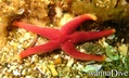
Intérêt bio Intéressant
Plus d'infos
Fréquentation semaine
Fréquentation week-end
Type de plongée
- Profonde
- Ambiance
Activités plongée
- Biologie Marine
- Plongée de nuit
- Formation
- Orientation
- Photographie
- Handicapés
Dangers
Informations supplémentaires
English (Traduisez ce texte en Français): The path down to the shoreline is around the right side of the FISH SHACK, and is a short scramble down small boulders to and easy walk to a small granite point jutting out into the water. This point offers easy water access and is 3-9' deep, depending on tide.
The diving is on a nice boulder slope running down to 40-50' to a gravel slope that gradually drops to ~100' deep. The rich seaweeds and marine life are in the top 40' of water.
It is calm in westerly winds, as it faces due east and is good for all level of divers in light northwest to southwest winds.
The path down to the shoreline is around the right side of the FISH SHACK, and is a short scramble down small boulders to and easy walk to a small granite point jutting out into the water. This point offers easy water access and is 3-9' deep, depending on tide.
The diving is on a nice boulder slope running down to 40-50' to a gravel slope that gradually drops to ~100' deep. The rich seaweeds and marine life are in the top 40' of water.
It is calm in westerly winds, as it faces due east and is good for all level of divers in light northwest to southwest winds.
English (Traduisez ce texte en Français): The path down to the shoreline is around the right side of the FISH SHACK, and is a short scramble down small boulders to and easy walk to a small granite point jutting out into the water. This point offers easy water access and is 3-9' deep, depending on tide.
The diving is on a nice boulder slope running down to 40-50' to a gravel slope that gradually drops to ~100' deep. The rich seaweeds and marine life are in the top 40' of water.
It is calm in westerly winds, as it faces due east and is good for all level of divers in light northwest to southwest winds.
 Commentaires
Tout voir (0)...
Soyez le(la) premier(e) à commenter ce pays
Erreurs, Réactions
Vous pouvez corriger des erreurs ou ajouter de nouvelles informations sur cette page. Si vous avez d'autres commentaires à faire sur cette page, Dite-le nous.
Wannadive.net 24/24
Wannadive.net sur votre portable

Newsletter Toutes les nouveautés par courriel
 The fish shack