Cette carte est interactive ! Utilisez les boutons pour zoomer ou vous déplacer.
Accès
|
English (Traduisez ce texte en Français): Access from route 655 from øye in too the mountain
English (Traduisez ce texte en Français): Access from route 655 from øye in too the mountain
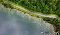
Access from route 655 from øye in too the mountain
English (Traduisez ce texte en Français): Access from route 655 from øye in too the mountain
English (Traduisez ce texte en Français): Access from route 655 from øye in too the mountain
English (Traduisez ce texte en Français): Access from route 655 from øye in too the mountain
English (Traduisez ce texte en Français): Access from route 655 from øye in too the mountain
English (Traduisez ce texte en Français): Access from route 655 from øye in too the mountain
English (Traduisez ce texte en Français): Access from route 655 from øye in too the mountain
Comment ? Depuis le bord
Distance Accès direct
Facile à trouver ? Facile à trouver
|
|
Caractéristiques du site
Autre nom Civilizatione lost
Prof. moyenne 10 m / 32.8 ft
Prof. max 18 m / 59.1 ft
Courant Pas de courant
Visibilité Bonne ( 10 - 30 m)
Qualité
Qualité du site Excellent
Expérience CMAS * / OW
Intérêt bio Aucun
Plus d'infos
Fréquentation semaine
Fréquentation week-end
Type de plongée
- Eau douce
Activités plongée
- Plongée de nuit
- PMT / Apnée
- Photographie
- Handicapés
Dangers
Informations supplémentaires
English (Traduisez ce texte en Français): A small village that was flooded after a rock slide that blocked the river that flows down the valley and formed an artificial lake and flooded a farm that still stands as one can see today
The lake is at an altitude of ca 200 meter's above sea level
English (Traduisez ce texte en Français): A small village that was flooded after a rock slide that blocked the river that flows down the valley and formed an artificial lake and flooded a farm that still stands as one can see today
The lake is at an altitude of ca 200 meter's above sea level
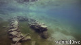
A small village that was flooded after a rock slide that blocked the river that flows down the valley and formed an artificial lake and flooded a farm that still stands as one can see today
The lake is at an altitude of ca 200 meter's above sea level
English (Traduisez ce texte en Français): A small village that was flooded after a rock slide that blocked the river that flows down the valley and formed an artificial lake and flooded a farm that still stands as one can see today
The lake is at an altitude of ca 200 meter's above sea level
English (Traduisez ce texte en Français): A small village that was flooded after a rock slide that blocked the river that flows down the valley and formed an artificial lake and flooded a farm that still stands as one can see today
The lake is at an altitude of ca 200 meter's above sea level
English (Traduisez ce texte en Français): A small village that was flooded after a rock slide that blocked the river that flows down the valley and formed an artificial lake and flooded a farm that still stands as one can see today
The lake is at an altitude of ca 200 meter's above sea level
English (Traduisez ce texte en Français): A small village that was flooded after a rock slide that blocked the river that flows down the valley and formed an artificial lake and flooded a farm that still stands as one can see today
The lake is at an altitude of ca 200 meter's above sea level
English (Traduisez ce texte en Français): A small village that was flooded after a rock slide that blocked the river that flows down the valley and formed an artificial lake and flooded a farm that still stands as one can see today
The lake is at an altitude of ca 200 meter's above sea level
English (Traduisez ce texte en Français): A small village that was flooded after a rock slide that blocked the river that flows down the valley and formed an artificial lake and flooded a farm that still stands as one can see today
The lake is at an altitude of ca 200 meter's above sea level
 Commentaires
Tout voir (0)...
Soyez le(la) premier(e) à commenter ce pays
Erreurs, Réactions
Vous pouvez corriger des erreurs ou ajouter de nouvelles informations sur cette page. Si vous avez d'autres commentaires à faire sur cette page, Dite-le nous.
Wannadive.net 24/24
Wannadive.net sur votre portable

Newsletter Toutes les nouveautés par courriel
 Lyngstølsvatnet