Cette carte est interactive ! Utilisez les boutons pour zoomer ou vous déplacer.
Accès
|
English (Traduisez ce texte en Français): Saranda bay
English (Traduisez ce texte en Français): Saranda bay
Saranda bay
English (Traduisez ce texte en Français): Saranda bay
English (Traduisez ce texte en Français): Saranda bay
English (Traduisez ce texte en Français): Saranda bay
English (Traduisez ce texte en Français): Saranda bay
English (Traduisez ce texte en Français): Saranda bay
English (Traduisez ce texte en Français): Saranda bay
Comment ?
Distance
Facile à trouver ?
|
|
Caractéristiques du site
Prof. moyenne 15 m / 49.2 ft
Prof. max 30 m / 98.4 ft
Courant
Visibilité
Qualité
Qualité du site
Expérience
Intérêt bio
Plus d'infos
Fréquentation semaine
Fréquentation week-end
Type de plongée
Activités plongée
Dangers
Informations supplémentaires
English (Traduisez ce texte en Français): Inside the Bay of Saranda there lies an Italian cargoship. It was sunk during the II World War by German Bombers on their way back from an attack on the Balkans. Traces of the bombs can still be seen on the ships sides! The vessel lies on its port side on the sandy bed at a maximum depth of 18m just 300m away from the shore. At the shallowest point the ship is just 3m form the surface and is marked with a bouy. The ship is roughly 115m long. It is marked above water by a Cardinal bouy signalling danger. Visibility underwater is good about 20m.
English (Traduisez ce texte en Français): Inside the Bay of Saranda there lies an Italian cargoship. It was sunk during the II World War by German Bombers on their way back from an attack on the Balkans. Traces of the bombs can still be seen on the ships sides! The vessel lies on its port side on the sandy bed at a maximum depth of 18m just 300m away from the shore. At the shallowest point the ship is just 3m form the surface and is marked with a bouy. The ship is roughly 115m long. It is marked above water by a Cardinal bouy signalling danger. Visibility underwater is good about 20m.
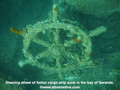
Inside the Bay of Saranda there lies an Italian cargoship. It was sunk during the II World War by German Bombers on their way back from an attack on the Balkans. Traces of the bombs can still be seen on the ships sides! The vessel lies on its port side on the sandy bed at a maximum depth of 18m just 300m away from the shore. At the shallowest point the ship is just 3m form the surface and is marked with a bouy. The ship is roughly 115m long. It is marked above water by a Cardinal bouy signalling danger. Visibility underwater is good about 20m.
English (Traduisez ce texte en Français): Inside the Bay of Saranda there lies an Italian cargoship. It was sunk during the II World War by German Bombers on their way back from an attack on the Balkans. Traces of the bombs can still be seen on the ships sides! The vessel lies on its port side on the sandy bed at a maximum depth of 18m just 300m away from the shore. At the shallowest point the ship is just 3m form the surface and is marked with a bouy. The ship is roughly 115m long. It is marked above water by a Cardinal bouy signalling danger. Visibility underwater is good about 20m.
English (Traduisez ce texte en Français): Inside the Bay of Saranda there lies an Italian cargoship. It was sunk during the II World War by German Bombers on their way back from an attack on the Balkans. Traces of the bombs can still be seen on the ships sides! The vessel lies on its port side on the sandy bed at a maximum depth of 18m just 300m away from the shore. At the shallowest point the ship is just 3m form the surface and is marked with a bouy. The ship is roughly 115m long. It is marked above water by a Cardinal bouy signalling danger. Visibility underwater is good about 20m.
English (Traduisez ce texte en Français): Inside the Bay of Saranda there lies an Italian cargoship. It was sunk during the II World War by German Bombers on their way back from an attack on the Balkans. Traces of the bombs can still be seen on the ships sides! The vessel lies on its port side on the sandy bed at a maximum depth of 18m just 300m away from the shore. At the shallowest point the ship is just 3m form the surface and is marked with a bouy. The ship is roughly 115m long. It is marked above water by a Cardinal bouy signalling danger. Visibility underwater is good about 20m.
English (Traduisez ce texte en Français): Inside the Bay of Saranda there lies an Italian cargoship. It was sunk during the II World War by German Bombers on their way back from an attack on the Balkans. Traces of the bombs can still be seen on the ships sides! The vessel lies on its port side on the sandy bed at a maximum depth of 18m just 300m away from the shore. At the shallowest point the ship is just 3m form the surface and is marked with a bouy. The ship is roughly 115m long. It is marked above water by a Cardinal bouy signalling danger. Visibility underwater is good about 20m.
English (Traduisez ce texte en Français): Inside the Bay of Saranda there lies an Italian cargoship. It was sunk during the II World War by German Bombers on their way back from an attack on the Balkans. Traces of the bombs can still be seen on the ships sides! The vessel lies on its port side on the sandy bed at a maximum depth of 18m just 300m away from the shore. At the shallowest point the ship is just 3m form the surface and is marked with a bouy. The ship is roughly 115m long. It is marked above water by a Cardinal bouy signalling danger. Visibility underwater is good about 20m.
English (Traduisez ce texte en Français): Inside the Bay of Saranda there lies an Italian cargoship. It was sunk during the II World War by German Bombers on their way back from an attack on the Balkans. Traces of the bombs can still be seen on the ships sides! The vessel lies on its port side on the sandy bed at a maximum depth of 18m just 300m away from the shore. At the shallowest point the ship is just 3m form the surface and is marked with a bouy. The ship is roughly 115m long. It is marked above water by a Cardinal bouy signalling danger. Visibility underwater is good about 20m.
 Commentaires
Tout voir (0)...
Soyez le(la) premier(e) à commenter ce pays
Erreurs, Réactions
Vous pouvez corriger des erreurs ou ajouter de nouvelles informations sur cette page. Si vous avez d'autres commentaires à faire sur cette page, Dite-le nous.
Wannadive.net 24/24
Wannadive.net sur votre portable

Newsletter Toutes les nouveautés par courriel
 Italian Freighter Probitas