Cette carte est interactive ! Utilisez les boutons pour zoomer ou vous déplacer.
Accès
|
English (Traduisez ce texte en Français): From the entrance to Malakal Harbor just around the North pincher a few yards. Often a mooring line on her
English (Traduisez ce texte en Français): From the entrance to Malakal Harbor just around the North pincher a few yards. Often a mooring line on her
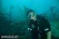
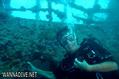
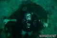
From the entrance to Malakal Harbor just around the North pincher a few yards. Often a mooring line on her
English (Traduisez ce texte en Français): From the entrance to Malakal Harbor just around the North pincher a few yards. Often a mooring line on her
English (Traduisez ce texte en Français): From the entrance to Malakal Harbor just around the North pincher a few yards. Often a mooring line on her
English (Traduisez ce texte en Français): From the entrance to Malakal Harbor just around the North pincher a few yards. Often a mooring line on her
English (Traduisez ce texte en Français): From the entrance to Malakal Harbor just around the North pincher a few yards. Often a mooring line on her
English (Traduisez ce texte en Français): From the entrance to Malakal Harbor just around the North pincher a few yards. Often a mooring line on her
English (Traduisez ce texte en Français): From the entrance to Malakal Harbor just around the North pincher a few yards. Often a mooring line on her
Comment ? Par bateau
Distance Court trajet par bateau (< 10min)
Facile à trouver ? Facile à trouver
|
|
Caractéristiques du site
Prof. moyenne 27 m / 88.6 ft
Prof. max 41 m / 134.5 ft
Courant Faible ( < 1 knot)
Visibilité Moyen ( 5 - 10 m)
Qualité
Qualité du site Excellent
Expérience Tous niveaux
Intérêt bio Intéressant
Plus d'infos
Fréquentation semaine
Fréquentation week-end
Type de plongée
- Epave
Activités plongée
- Biologie Marine
- Plongée de nuit
- Formation
- Photographie
Dangers
Informations supplémentaires
English (Traduisez ce texte en Français): 502 Foot length, 66 Foot beam
10,000 Ton, Combined Fleet Tanker
Stinging Hydroids cover the marker buoy line to the ship.
She was attacked by aircraft from the Carrier Enterprise as part of Task Force 58, Operation Desecrate One, on March 30 and finished off the later that day by aircraft from the same Carrier .
502 Foot length, 66 Foot beam
10,000 Ton, Combined Fleet Tanker
Stinging Hydroids cover the marker buoy line to the ship.
She was attacked by aircraft from the Carrier Enterprise as part of Task Force 58, Operation Desecrate One, on March 30 and finished off the later that day by aircraft from the same Carrier .
English (Traduisez ce texte en Français): 502 Foot length, 66 Foot beam
10,000 Ton, Combined Fleet Tanker
Stinging Hydroids cover the marker buoy line to the ship.
She was attacked by aircraft from the Carrier Enterprise as part of Task Force 58, Operation Desecrate One, on March 30 and finished off the later that day by aircraft from the same Carrier .
 Commentaires
Tout voir (0)...
Soyez le(la) premier(e) à commenter ce pays
Erreurs, Réactions
Vous pouvez corriger des erreurs ou ajouter de nouvelles informations sur cette page. Si vous avez d'autres commentaires à faire sur cette page, Dite-le nous.
Wannadive.net 24/24
Wannadive.net sur votre portable

Newsletter Toutes les nouveautés par courriel
 Amatsu Maru