Mot de passe perdu ?
Nouvel utilisateur ? Créer un compte
Clownfish, Philippines. Photo by Stephane Rochon.
Appréciez et contribuez !
| Trouvez les meilleurs sites |
|
|
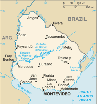
 Uruguay
Amérique du sud
Localisation: Southern South America, bordering the South Atlantic Ocean, between Argentina and Brazil
Coordonnées géographiques: 33° 0' S, 56° 0' W
Côte: 660 km km
Climat: warm temperate; freezing temperatures almost unknown
Relief: mostly rolling plains and low hills; fertile coastal lowland
Sommets: lowest point: Atlantic Ocean 0 m
highest point: Cerro Catedral 514 m
Risques naturels: seasonally high winds (the pampero is a chilly and occasional violent wind that blows north from the Argentine pampas), droughts, floods; because of the absence of mountains, which act as weather barriers, all locations are particularly vulnerable to rapid changes from weather fronts
Monnaie: Uruguayan peso (UYU)
Population: 3,477,778 (July 2008 est.)
Langues: Spanish, Portunol, or Brazilero (Portuguese-Spanish mix on the Brazilian frontier)
Capitale: Montevideo
Découpage administratif: 19 departments: Artigas, Canelones, Cerro Largo, Colonia, Durazno, Flores, Florida, Lavalleja, Maldonado, Montevideo, Paysandu, Rio Negro, Rivera, Rocha, Salto, San Jose, Soriano, Tacuarembo, Treinta y Tres
Plus d'informations
| Jan | Feb | Mar | Apr | May | Jun | Jul | Aug | Sep | Oct | Nov | Dec | |
|---|---|---|---|---|---|---|---|---|---|---|---|---|
| Climate | ||||||||||||
| Air temp. | ||||||||||||
| Water temp. | ||||||||||||
| Equipment | No sé | No sé | No sé | No sé | No sé | No sé | No sé | No sé | No sé | No sé | No sé | No sé |
| Best season | ||||||||||||
Carte
Vous voulez ajouter des informations sur Uruguay? Dites-le nous...
Cette carte est interactive ! Utilisez les boutons pour zoomer ou vous déplacer.
- Favoris
-
Vos sites favoris et futures listes de sites
Sites de plongée
| Sites de plongée (11) | Qualité | Prof moy | Prof max | Expérience | Type de plongée | ||
|---|---|---|---|---|---|---|---|
| Cantera El Terrible | 4 / - | 14.8 ft | 16.4 ft | Tous niveaux | 

|
||
| Cantera El Terrible (Grande) | 3 / - | 32.8 ft | 39.4 ft | CMAS * / OW |
|
||
| Cantera Ferrando | 8 / - | 13.1 ft | 26.2 ft | Tous niveaux |
|
||
| Cantera Riachuelo | - / - | 9.8 ft | 65.6 ft | Tous niveaux |

|
||
| Jose Ignacio | - / 1 | 8.2 ft | 14.8 ft | Tous niveaux | 

|
||
| Piriapolis Vertigo | 1 / - | 6.6 ft | 13.1 ft | Tous niveaux |
|
||
| Playa Mansa, Punta del Este | - / - | 13.1 ft | 16.4 ft | CMAS ** / AOW | |||
| Puertito de Don Anselmo | - / - | 6.6 ft | 16.4 ft | Tous niveaux |
|
||
| Punta Ballena | 2 / - | 16.4 ft | 39.4 ft | Tous niveaux | 
|
||
| Punta Colorada | - / - | 6.6 ft | 19.7 ft | Tous niveaux |
|
||
| Stella Maris | 1 / - | 6.6 ft | 16.4 ft | Tous niveaux |

|
 Photos
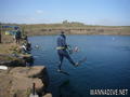
Cantera El Terrible |

Cantera El Terrible |
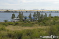
Cantera El Terrible Grande |

Cantera El Terrible Grande |

Dernières plongée
|
Commentaires
Soyez le(la) premier(e) à commenter ce pays
Erreurs, Réactions
Si vous voulez ajouter de nouvelles informations ou si vous avez trouvé des erreurs sur cette page, Dite-le nous.
Annonceurs
Wannadive.net 24/24
Wannadive.net sur votre portable
![]()
RSS Tous les flux RSS de Wannadive.net
Newsletter Toutes les nouveautés par courriel