Mot de passe perdu ?
Nouvel utilisateur ? Créer un compte
Whale Shark, Philippines. Photo by Stephane Rochon.
Appréciez et contribuez !
| Trouvez les meilleurs sites |
|
|
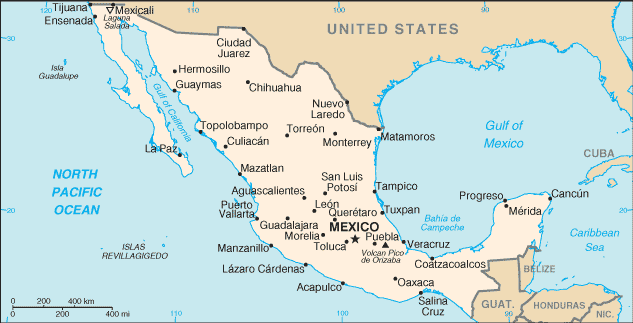
 Mexico
Amérique centrale
Localisation: Middle America, bordering the Caribbean Sea and the Gulf of Mexico, between Belize and the US and bordering the North Pacific Ocean, between Guatemala and the US
Coordonnées géographiques: 23° 0' N, 102° 0' W
Côte: 9,330 km km
Climat: varies from tropical to desert
Relief: high, rugged mountains; low coastal plains; high plateaus; desert
Sommets: lowest point: Laguna Salada -10 m
highest point: Volcan Pico de Orizaba 5,700 m
Risques naturels: tsunamis along the Pacific coast, volcanoes and destructive earthquakes in the center and south, and hurricanes on the Pacific, Gulf of Mexico, and Caribbean coasts
Monnaie: Mexican peso (MXN)
Population: 106,202,903 (July 2005 est.)
Langues: Spanish, various Mayan, Nahuatl, and other regional indigenous languages
Capitale: Mexico
Découpage administratif: 31 states and 1 federal district* ; Aguascalientes, Baja California, Baja California Sur, Campeche, Chiapas, Chihuahua, Coahuila de Zaragoza, Colima, Distrito Federal*, Durango, Guanajuato, Guerrero, Hidalgo, Jalisco, Mexico, Michoacan de Ocampo, Morelos, Nayarit, Nuevo Leon, Oaxaca, Puebla, Queretaro de Arteaga, Quintana Roo, San Luis Potosi, Sinaloa, Sonora, Tabasco, Tamaulipas, Tlaxcala, Veracruz-Llave, Yucatan, Zacatecas
Plus d'informations
| Jan | Feb | Mar | Apr | May | Jun | Jul | Aug | Sep | Oct | Nov | Dec | |
|---|---|---|---|---|---|---|---|---|---|---|---|---|
| Climate | ||||||||||||
| Air temp. | ||||||||||||
| Water temp. | ||||||||||||
| Equipment | ||||||||||||
| Best season | ||||||||||||
Carte
Vous voulez ajouter des informations sur Mexico? Dites-le nous...
Cette carte est interactive ! Utilisez les boutons pour zoomer ou vous déplacer.
- Favoris
-
Vos sites favoris et futures listes de sites
Votre zone préféré n'est pas présente ? Ajouter une zone
zones
| zones (9) | Sites de plongée | Sous-zones |
|---|---|---|
| Baja California | 48 | 5 |
| Capital Region | 2 | 1 |
| Central Highlands | 2 | 0 |
| Central Pacific | 24 | 3 |
| Islas Revillagigedos | 6 | 0 |
| Northeast - Monterrey | 1 | 0 |
| Northwest - Sinaloa & Sonora | 35 | 3 |
| Southern Gulf of Mexico | 10 | 1 |
| Yucatán Peninsula | 123 | 9 |


 Dernières plongée
|
Derniers voyages
|
Commentaires
De schris , 11-04-2018
Use wannadive zone download link - There are only two dive site for now in this area; you can download them from https://www.wannadive.net/spot/Central_America/Mexico/Baja_California/La_Paz___Isla_Partida/ See the download link and click on the available output format.
De dfb72es , 10-04-2018
COORDENADAS GPS - HOLA A TODOS, ESTOY EN LA BÚSQUEDA DE COORDENADAS GPS DE TODO LO QUE ESTE SUMERGIDO EN LA ZONA DE LA PAZ BCS MX.
GRACIAS
Erreurs, Réactions
Si vous voulez ajouter de nouvelles informations ou si vous avez trouvé des erreurs sur cette page, Dite-le nous.
Annonceurs
Wannadive.net 24/24
Wannadive.net sur votre portable
![]()
RSS Tous les flux RSS de Wannadive.net
Newsletter Toutes les nouveautés par courriel